
Turtle Hatchery Programme
Detail
The TIC scientists based at the Tengah Island Hatchery collect data on endangered green and critically endangered hawksbill turtles in strategic partnership with the Department of Fisheries, Malaysia.
We do this to protect the populations of the turtles, and to increase turtle hatchlings survival rates through best-practices in effective hatchery management and awareness. The programme includes morning boat patrols of the neighbouring islands in order to try and encounter nests before they are either poached or predated. Regular nightly patrols of the island are also scheduled to try and encounter and tag nesting females. We have introduced temperature loggers into the nests in order to monitor the temperature profile over time and try to understand how temperature may influence hatching success and gender ratio. We are working towards a programme to sample the DNA of the hatchlings in order to study the population dynamics and parentage, as well as deploy satellite tags on nesting females in order to track their migratory routes and better advocate for their protection.
Malaysian Sea Turtle Photo ID Network
In sea turtle research, the use of photo identification has been proposed and tested as a reliable method for individual recognition, as each individual possess unique facial scales patterns.
In 2017 the Malaysian Sea Turtle Photo Identification Network was initiated with the goal of establishing a regional-wide shared database to gain knowledge about the spatial-temporal pattern of sea turtles. With the establishment of the photo ID network, the movement, habitat usage and site fidelity of sea turtle will be better documented.
In 2018, TIC joined this network by collecting facial pictures of sea turtles spotted underwater or during their nesting process, and sharing the data with the relevant partners and government authorities. The photos collected are analysed using the I3S software which identifies spot patterns in the individual of interest, compares his pattern against all animals in the database, and shows the closest matches to the individual been analysed.
Sea turtle population studies in Malaysia to date have mostly relied on Inconel flipper tags or other physical markers to identify individuals. While most female turtles are tagged during nesting, little is known about their movements between foraging and nesting sites in Malaysian waters. Furthermore, there is even less information available about the movement of males as they are rarely tagged.
Lastly, these intrusive methods are not entirely successful as the tags can easily become dislodged from the flipper, thus prompting the establishment of a photo identification network to compliment the current tagging system.
Photographic identification has been increasingly used by various projects around the world as a reliable tool to track individuals over time, providing details on a species’ population dynamics.

Survey. Map. Restore
CORAL REEF PRESERVATION & MONITORING.
In addition to Tengah Island Hatchery, TIC runs a wider marine conservation programme which includes coral reef mapping on Pulau Tengah and other Johor Islands, coral reef surveys and monitoring, reef restoration and other habitat studies with published scientific reports distributed quarterly. This work is carried out in Strategic Partnership with the Department of Fisheries, Malaysia.
Monitoring
Coral reefs are one of the most diverse ecosystems on the planet. They are home to millions of species of plants and fish that people depend on for food, medicines and tourism. They also serve as barriers in many areas to protect lives and properties from storms, waves, and the forces of erosion. Coral reef monitoring and assessment are important tools for effective management and can provide information to detect changes in reef conditions.
Mapping
TIC is in the process of GPS mapping the coral reefs around the Pulau Tengah to determine their exact sizes and locations. This will help to determine reef growth and health over time, as well as allow appropriate planning for coral replanting and placement of mooring lines and buoy lines.
Surveys
Annual Reef Check surveys are conducted and bolstered this with our own in-house monitoring to study the coral and marine life in more detail over time. We also conduct Rapid Ecological Assessment Methods (REA), — comprehensive, small scale, site-specific surveys — to monitor temporal and spatial variations in marine habitats and populations. This non-invasive technique allows the collection of community level data by monitoring the abundance of coral reef organisms. These activities allow us to evaluate the coverage and health of the coral reefs surrounding Pulau Tengah.
Nursery and Restoration—in-situ & ex-situ
TIC has deployed several coral nurseries around Pulau Tengah using the latest research to determine the most successful techniques for our region. So far, the nurseries have been highly successful with up to 5cm growth per month.

TIC Marine Scientist measured the growth of the coral nursery at one of the sites.

As part of our habitat restoration project we have 2 techniques for attaching coral; coral biscuits and cable ties. Each month we measure the height and the width of each coral fragment.
This is to identify if the method we use for attaching has an impact on the growth rate, and to gauge when they are ready to be transplanted back on to the reef. Our Acropora corals will grow between 3 and 5 cm each month.
Terrestrial Projects
Erosion and Accretion Patterns Monitoring
BEACH PROFILE MONITORING
Changes in the beach area caused by erosion or accretion patterns can be monitored by temporal measurements of beach profiles. Beach profile data can be used in numerous ways to guide decision-making in coastal areas, such as monitoring beach nourishment and dune restoration projects. In 2018, the TIC team conducted monthly beach profile surveys on 11 beaches of Pulau Tengah.
Beach profiles are measured from a fixed point at the back of the beach (the reference marker) towards the ocean. The profile is measured in segments, which can either be a fixed distance or can vary depending on the profile of the beach, i.e. each change in slope is the start of a new segment. TIC follows the Abney method to measure the profile of beaches, which requires an Abney level and two poles to measure the distance (z) and slope (a) of each beach segment. Elevation is then calculated to produce the beach profile.


Study Beach Pattern Change and Corrosion.
Sand Stabilising Species Growth. Promote Biodiversity.
INDIGENOUS TREE NURSERY
As a result of continuous coastal erosion and introduction of exotic flora species over the past years, our team created a Tree Nursery to allow the growth of sand stabilizing species and to promote biodiversity by removing non-native invasive plants. Once matured, these plants/trees will be replanted along our coastline to support the beaches against erosion caused by wave action and weather, whilst maintaining a healthy, indigenous and flourishing terrestrial environment.
The nursery houses 7 different species of trees - Scaveola taccada (Beach Cabbage), Hibiscus tiliaceus (Sea Hibiscus), Barringtonia asiatica (Sea Poison Tree), Calophyllum inophyllum (Alexandrian Laurel Tree), Terminalia catappa (Indian Almond Tree) – from which two are mangrove species - Nypa fruticans (Magrove Palm), Rhizophora mucronata (Mangrove Tree). Mangrove species help to buffer coastlines from severe weather and flooding as well as reducing sediment runoff which in turn helps to protect our coral reefs.
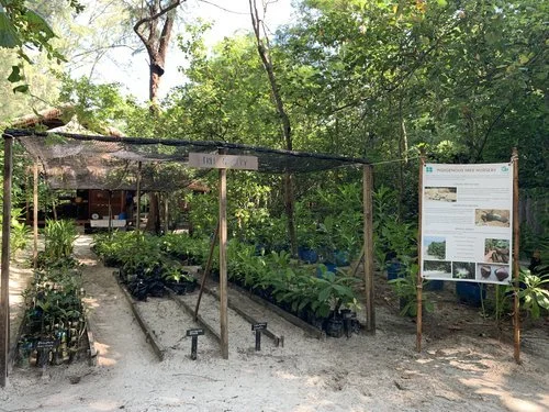
TIC Indigenous Tree Nursery
This is where TIC grow native plants before moving them to their permanent locations around the island.

